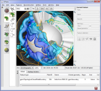
Interactive visualization of plate-tectonics
GPlates Portable is an interactive plate-tectonics visualisation program. GPlates Portable enables interactive visualisation and manipulation of the plate-tectonic reconstructions of geological and paleo-geographic features through geological time.
Operating system:Windows XP / Vista / 7 / 8 / 8 64 bit

Learn world continents and oceans the fun way. Includes 5 games. Continent and ocean names are spoken. A map of the globe is included.
Price: $0, Rating: 10, Downloads: 63
Download

Schmap France contains travel guides for nine popular French cities (including Paris, Cannes and Nice). Each guide comes with dynamic maps, useful links, playable tours, top picks, plus photos and reviews for 100s of attractions, restaurants, shops.
Price: $0, Rating: 7, Downloads: 60
Download
Satellite Image Browser is a Shareware Mac OS X application that can be used to display and print topographical satellite images.
Price: $20.00, Rating: 6, Downloads: 58
Download

Want to brush up on the names and locations of the 50 or so countries of modern Africa? This program from the Family Games Web Center will help you. A study mode and two quiz modes make the learning easy.
Price: $0.00, Rating: 10, Downloads: 50
Download

Visualize the location of all the countries of the world. Use as a reference to locate countries whose location you are curious about. Use it to test your knowledge of the world by having the program prompt you to find certain countries.
Price: $19.95, Rating: 8, Downloads: 49
Download